Manitoba - Northwest Territories - Nunavut - Saskatchewan Multi-point
| Coordinates (NAD27) |
N59ş59'59.6" W102ş00'22.3" |
| UTM Coordinates (NAD27) |
13V 666960 6654920 |
| UTM Coordinates (WGS84) |
|
| Elevation |
0 feet (0.0 meters) |
Description
The
boundary junction of Manitoba, Northwest Territories, Nunavut, and Saskatchewan is marked by a meter high aluminum obelisk. The monument was
placed in 1962 and predates the existence of Nunavut (April, 1999). The north side is inscribed "Northwest Territories", the east side
"Manitoba", the west side "Saskatchewan", and the south side "Manitoba Saskatchewan Boundary Commission 1962". Near the top of the south
side is "BM", presumably indicating a benchmark. On top of the monument is a disc containing a warning about five years in jail for removing
or destroying the monument. Reaching this point involves some significant logistical challenges and requires advance planning. The
monument is in a muskeg between Kasba Lake to the north and Hasbala Lake to the south. The best approach is from Hasbala Lake, which is
about 140 miles by air from the nearest float plane facility at Points North Landing, Saskatchewan. Points North Landing is at the end of
Saskatchewan Provincial Highways 102 and 905, gravel roads beginning 265 miles to the south in La Ronge, Saskatchewan.
On July 19, 2001
we drove the length of SK102 and SK905 (about 7 hours) and reached Hidden Bay on Wollaston Lake, about 20 miles southeast of Points North
Landing, where we set up camp. The next day we drove to Points North Landing to check on the status of our flight on July 21. We were
scheduled to fly on a freight flight to Hasbala Lake Lodge, an arrangement we had made some months earlier. Early on the 21st we drove back
to Points North Landing for the flight but the airstrip was fogged in. The fog lifted at about 8 A.M. and we took off in a de Havilland
Beaver with Hugh Fischer at the controls. The plane carried the pilot, the two of us, and a load of groceries for the camp on Hasbala Lake.
About 75 miles out we encountered a heavy overcast and a solid black wall to the north so we headed back to Points North Landing. Later in
the afternoon we tried again but rain and wind prevented air operations. The next day at 6 A.M. we were ready but one of the plane's floats
was submerged with a puncture and required repairs, which turned out to be more extensive than expected. At about 2 P.M. the air service
decided to use a different plane and deliver a larger freight shipment to the camp. We boarded a de Havilland Single Otter with Dean
Greabeiel at the controls and Matt Ryan also in the cockpit. The plane was loaded with wood siding, groceries, frozen meat, and other
supplies. Bucking 40 knot headwinds the entire way, our flight took about 1 hour and 45 minutes, averaging only about 80 mph ground speed.
The views of the forest, lakes, muskegs, rocks, and sand were very good because we flew only about 600 feet above the ground.
At
Hasbala Lake, we helped unload the plane and reload it with empty fuel drums, propane cylinders, and garbage. We then boarded an aluminum
fishing boat manned by guide Ron Misponas, and motored about 1.5 miles across the lake. From here we walked several hundred meters through
muskeg and hordes of mosquitos to the monument. A surveyors' tower constructed of local black spruce stands nearby. We assume it was built
in 1962. It now serves as a scaffold for a large osprey nest. We took a number of photographs and returned to the camp and plane. The
return flight was very fast. Supper at Points North Landing was great.
If you are planning to visit this point, start by contacting
Hasbala Lake Lodge. Morice Miller, the proprietor, can help with air, boat, and guide services. His camp is open from about June 1 (when the
ice is out) until September 1 (when the ice returns).
Photos (click to enlarge)
 |
Saskatchewan Highway 905. We travelled 265 miles of this road
to reach the airfield at Points North Landing.
Photo by Brian J. Butler |
 |
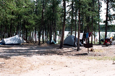
Base camp at Hidden Bay, Wollaston Lake, Saskatchewan. We
camped here for four days waiting for acceptable flying weather. This camp is located about 32 km from Points North Landing.
Photo by Brian J.
Butler |
 |
We were glad to see this sign at the end of Saskatchewan
905 and a kilometer from Points North Landing. Actually, at the time of our visit the road was open for 4WD traffic all the way to Stony
Rapids on Lake Athabasca, 180 km NW.
Photo by Brian J. Butler |
 |
Fog at Points North Landing delayed our departure on July 21, 2001 and
forced our plane to return from 75 miles out. The weather did not improve until the afternoon of July 22.
Photo by Brian J. Butler |
 |
The camp at Points North Landing. This is a
transportation hub for the area, providing wheeled aircraft, float planes, and heavy truck transportation for several nearby uranium mines
and Indian settlements. Gasoline, lodging, and meals are also available here.
Photo by Brian J. Butler |
 |
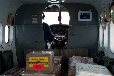
Eventually we boarded a freight flight bound for Hasbala Lake
Lodge, about a mile and a half south of the quad-point. In addition to Brian and Gregg Butler, the plane carried wooden siding, food, and
fuel for the fishing camp. It was a fairly bumpy flight due to a strong headwind.
Photo by Brian J. Butler |
 |
Our plane, the "Blue Canoe", being unloaded at Hasbala Lake
Lodge.
Photo by Brian J. Butler |
 |
Hasbala Lake looking in the direction of the quad-point.
Photo was taken from the bow of the motorboat used by the guide who took us to a landing near the point.
Photo by Brian J. Butler |
 |
The monument at Canadian Four Corners. Since the monument was
set in 1962 it does not mention Nunavut
Photo by Brian J. Butler |
 |
Brian Butler (left) and Gregg Butler (right) at Canadian
Four Corners on July 22, 2001.
Photo by Dean Greabeiel |
 |
The crew that helped us reach Canadian Four Corners. Our Hasbala Lake
guide Ron Misponas (left), bush pilot Dean Greabeiel (center), assistant (and pilot in training) Matt Ryan (right).
Photo by Brian J. Butler |
 |
A surveying tower made of black spruce logs. We assume this was
built in 1962. There are remnants of a large osprey nest. This structure stands about 100 feet north of the quad-point, which is visible
near the bottom of the photo.
Photo by Brian J. Butler |
 |
The flight back to Points North Landing carried empty fuel
drums, propane cylinders, trash, the crew and two passengers. The pilot was smoking, but at least he had his window open.
Photo by Brian J.
Butler |
 |
Back on Saskatchewan 905 headed south. Pavement never felt
so good as when we reached La Ronge.
Photo by Gregg A. Butler |
|