Connecticut - Massachusetts - New York Tri-state
| Coordinates (NAD27) |
N42ş02'58.1" W73ş29'16.0" |
| UTM Coordinates (NAD27) |
18T 625145 4656155 |
| UTM Coordinates (WGS84) |
18T 625143 4656374 |
| Elevation |
2145 feet (653.8 meters) |
Description
This
tri-state monument was set during an 1898 survey of the Massachusetts - New York boundary. Consequently "Connecticut" is not inscribed on
the stone, but resourceful visitors frequently paint "Conn" on the side facing the Nutmeg State. The monument is easy to reach during summer
by taking Mt. Washington Rd. in Salisbury, CT (a.k.a. East Street in Mt. Washington, MA) to a trailhead on the W side of the road at
coordinates UTM 18T 626455E 4654438N and
following the trail NW approximately 1 mile. A hundred feet before the trail crosses Monument Brook a side trail diverges N (CT-MA boundary
monument a few yards N) and climbs moderately to a clearing and the tri-state monument.
Mt. Washington Road/East Street is closed
during winter. The tri-state monument is also accessible via trails in the Mt. Washington State Forest (MA) and Taconic State Park (NY). An
excellent trail map is available from the New York - New Jersey Trail Conference.
Photos (click to enlarge)
 |
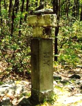
The tri-state monument, showing the NY and 1898 sides. The stone
fragments in the foreground are remnants of an earlier monument dating from an 1853 survey of the MA-NY line.
Photo by Brian J. Butler |
 |
Visitors frequently arrange the remnants in novel configurations.
Photo by Brian J. Butler |
 |
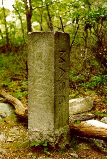
There is usually an ersatz Connecticut inscription like the one
shown here.
Photo by Brian J. Butler |
 |
The author after adding a log to the cairn.
Photo by Brian J. Butler |
 |
The author, Clem, and his tri-state hunting dog.
Photo by Brian J.
Butler |
|